Independently Owned, Locally Grown, Community Loved


By Dr Bianka Vidonja Balanzategui
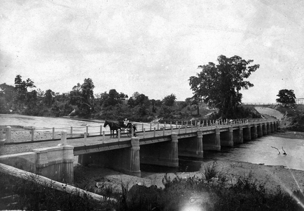
Since its opening on 4 November 1891 the Gairloch Bridge, on the old Bruce Highway, has been crossed by countless vehicles, buggies, bicycles, tractors, cars and pedestrians. Bull sharks and crocodiles have been spied from the safety of its span. It has been fished and dived off, and sadly, people have lost their lives crossing it.
When in June 1903, Mrs Norah Judge and her four-year-old son James approached the bridge in their buggy, the horse baulked at the kerb, sending horse, buggy and occupants into the river. This tragedy devastated the lower Herbert community; Norah was made a widow a year before and now left three children aged between one and eight years, parentless. A contributing factor to their deaths was that the bridge chains and uprights were removed at the time of the previous flood and not replaced, and the bridge was out of repair and dangerous. Despite the bridge’s unique construction and design to withstand floods, a Herbert River on rampage is a formidable force to be reckoned with.
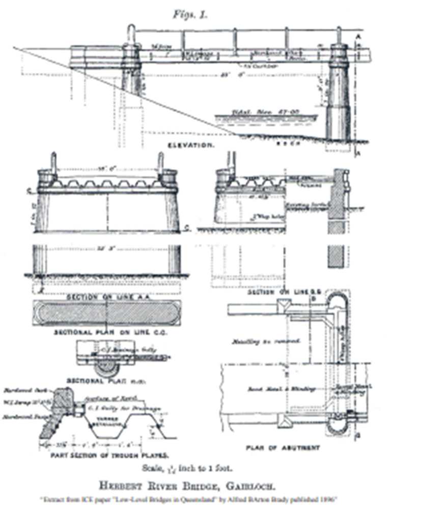
The sugar industry of the Herbert River district had its beginnings in the lower Herbert with the Gairloch Plantation Mill, which crushed for the first time in 1872. But by 1885, sugar cultivation had spread north of the Herbert River and a bridge was required to access that cane. The Divisional Board raised the money to build the bridge after a petition to Government for funds was unsuccessful. A Government architect, Alfred Barton Brady, was engaged to design the bridge. It was his first road bridge and James Graham was contracted to build it.
A small township of tents and a boarding house sprung up alongside the construction site to house the workers who, because of frequent flooding which delayed the construction, were on the site for nearly two years. While the bridge did not save the Gairloch Plantation Mill, its history is preserved in the bricks (salvaged from the dismantlement of the mill) shoring up the steepest approach to the bridge.
The 14-span bridge stood a comfortable 11 feet (3 metres) above the usual summer level of the river and a frightening 28 feet (8.5 metres) below the highest flood level. Though the submersible bridge was designed to provide the least possible obstruction to the flow of flood waters and the debris they carry, historically major floods have always caused damage. The first were those of 1892 and then 1894. Now in 2025, the bridge is closed to even foot traffic because of the damage caused by the latest flood.
It is the only known road bridge of this design built in the 19th century in Australia and has a number of features that were innovative for its time. Rather than timber decking, mild steel trough plate filled with tarred metal, placed longitudinally, were used. These dispensed with girders. And though this was a more costly design, it meant that the bridge offered little resistance to coursing flood waters.
However, long term, its construction was more cost effective because being low level and submersible. The construction of the bridge is also significant for the use of Portland cement in the piers, abutments and string courses. After the 1894 flood the original asphalt filling of the steel troughs was replaced by Portland cement concrete which also provided improved resistance to degradation. This use of concrete in the deck is the earliest type of this form of construction in Australia.
The deep approaches cut through the sandbanks were shored by bricks or logs on the approaches, and washaways at those points impacted the bridge and surrounding land significantly over the years. It is recorded that “an evident engineering mistake was made in not consolidating the cutting on the North side similar to that on the Eastern bank. With the big flood of 1894, the river broke through on the north side and caused the big washaway, which successive floods attack with unabated fury. In that memorable landslide of 1894, Mr. E. Farr had a store and residence on the top of the bank and it was completely engulfed on the night of April 9th. 1894, the occupants being removed to safety only a few hours previously. A bullock waggon loaded with provisions was tethered to a big tree by a stout chain, near the scene of the wash-away, but tree and waggon completely disappeared, and only a few years ago a yoke was fished up many miles away, this being all that has been found.”
The costs of maintaining the bridge were high, and once the John Row Bridge was built in 1967, the Gairloch Bridge became redundant to all but local traffic, with an Engineering Heritage Marker and interpretative board being placed on the approach to Gairloch Bridge in 18 March 2014. Though untrafficable now, it is vital that this bridge is maintained at least for foot traffic because of its heratige status.
Publishers Indemnity. Any individual or entity that places advertising, supplies copy material, or submits editorial content to Life Publishing agrees and undertakes to ensure that all such material:- Does not infringe upon any copyright, trademark, or other intellectual property rights;- Is free from any content that could be considered defamatory, libelous, or slanderous;- Does not infringe upon any rights related to privacy or breach of confidence;- Contains no obscene, indecent, or otherwise unlawful material;- Complies fully with the Trade Practices Act and all other applicable laws, regulations, or statutes. Furthermore, by submitting or placing such material, these individuals or entities agree to indemnify and hold harmless the publisher, Life Publishing and Events Pty Ltd, and/or its agents from and against any and all investigations, claims, demands, liabilities, damages, costs, or judgments arising out of or in connection with the material provided. All material is believed to be accurate at the time of printing and remains the copyright of Life Publishing and Events Pty Ltd.
View editorial standards and complaints policy here
© 2026 Life Publishing Group Ltd.